![](/images/other/stat-length.png)
![Randonnée Marche Les Bréviaires - Yvelines_Croix-de-Vilpert=>Montfort-L'Amaury - Photo](https://media.geolcdn.com/t/1900/400/ext.pjpeg?maxdim=2&url=https%3A%2F%2Fstatic1.geolcdn.com%2Fsiteimages%2Fupload%2Ffiles%2F1553511878bg_sport_marche.png)
Yvelines_Croix-de-Vilpert=>Montfort-L'Amaury
BMorin91470
Utilisateur
![Longueur](/images/other/stat-length.png)
![Altitude max](https://static1.geolcdn.com/siteimages/upload/files/1508320355ic_sort_altitude_max_24dp.png)
![Dénivelé positif](https://static1.geolcdn.com/siteimages/upload/files/1508320355ic_sort_den_pos_24dp.png)
![Km-Effort](/images/other/stat-length.png)
![Altitude min](https://static1.geolcdn.com/siteimages/upload/files/1508320355ic_sort_altitude_min_24dp.png)
![Dénivelé négatif](https://static1.geolcdn.com/siteimages/upload/files/1508320355ic_sort_den_neg_24dp.png)
![Boucle](https://static1.geolcdn.com/siteimages/upload/files/16400158638029165_repeat_loop_refresh_sync_direction_icon.png)
![Marche](https://static1.geolcdn.com/sitytour/trail-icons/101.png)
5h00
Difficulté : Moyen
![Scannez ce code QR pour ouvrir la randonnée dans l'application SityTrail](https://capi.geolives.com/qq0zvz2zws4bq2lad0pu/sitytour/trails/1141207/qr.png?size=200)
Application GPS de randonnée GRATUITE
À propos
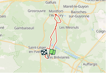
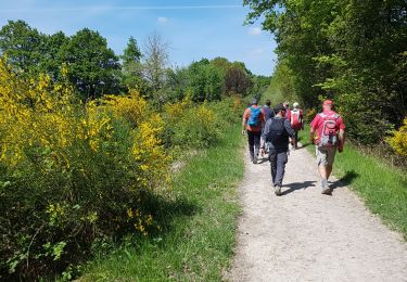
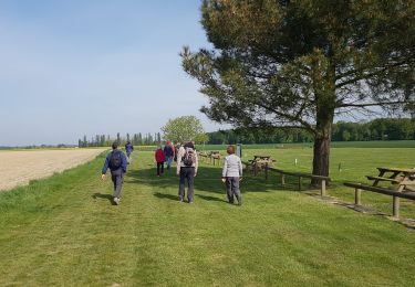
Randonnée Marche de 19,6 km à découvrir à Île-de-France, Yvelines, Les Bréviaires. Cette randonnée est proposée par BMorin91470.
Description
CRAPAHU : Circuit Rando journée
Départ: Croix de Vilpert
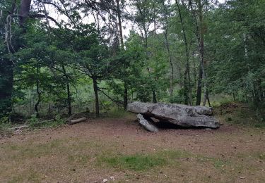
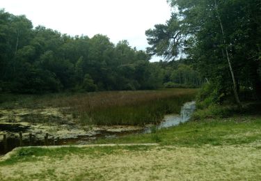
Destination : Montfort l'Amaury (Les Tours) par route de la Croix de Vilpert, Carrefour Judith, Table du Roi, Carrefour de Montaval,Étang de la Porte Baudet, Étang de la Plaine, arrivée à Montfort par la place de la Tripière, montée aux Tours et pique-nique.
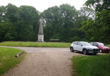
Visite de Montfort: les Tours, le Cloitre et l’Église
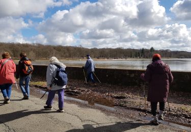
Retour vers la Croix de Vilpert par le chemin du poteau, l’Étang de la Porte Baudet, la route Belsédene, la Chaussée de Hollande, carrefour des Mares Gauthier et Croix de Vilpert
Randonnée journée réalisée le 05/05/2019
Localisation
Commentaires
Randonnées à proximité
![Randonnée Marche Saint-Léger-en-Yvelines - Yvelines_Croix-Vilpert=>Rochers-d'Angennes=>Petit-Etang-Neuf - Photo](https://media.geolcdn.com/t/375/260/6d489e7d-9a8c-4142-91a9-ca62eb9af4d0.jpg&format=jpg&maxdim=2)
![Marche Marche](https://static1.geolcdn.com/sitytour/trail-icons/101.png)
Marche
![](/images/other/stat-length.png)
![](https://static1.geolcdn.com/siteimages/upload/files/16400158638029165_repeat_loop_refresh_sync_direction_icon.png)
![Randonnée Marche Poigny-la-Forêt - Sortie du 25/06/2015 - Photo](https://media.geolcdn.com/t/375/260/ext.jpg?maxdim=2&url=https%3A%2F%2Fservices.sitytrail.com%2FGeolivesWS%2FDownloadMedia.ashx%3FTrailID%3D438058%26Media%3Dfix__20150625121933.jpg)
![Marche Marche](https://static1.geolcdn.com/sitytour/trail-icons/101.png)
Marche
![](/images/other/stat-length.png)
![](https://static1.geolcdn.com/siteimages/upload/files/16400158638029165_repeat_loop_refresh_sync_direction_icon.png)
![Randonnée Marche Poigny-la-Forêt - poigny - Photo](https://media.geolcdn.com/t/375/260/4048684d-3aec-49d6-ad34-88a4a7b23eb9.jpg&format=jpg&maxdim=2)
![Marche Marche](https://static1.geolcdn.com/sitytour/trail-icons/101.png)
Marche
![](/images/other/stat-length.png)
![](https://static1.geolcdn.com/siteimages/upload/files/16400158638029165_repeat_loop_refresh_sync_direction_icon.png)
![Randonnée Marche Poigny-la-Forêt - Rochers d'Angennes Yvelines - Photo](https://media.geolcdn.com/t/375/260/84e3942c-3b91-4957-8e21-15467325743e.jpg&format=jpg&maxdim=2)
![Marche Marche](https://static1.geolcdn.com/sitytour/trail-icons/101.png)
Marche
![](/images/other/stat-length.png)
![](https://static1.geolcdn.com/siteimages/upload/files/16400158638029165_repeat_loop_refresh_sync_direction_icon.png)
![Randonnée Marche Rambouillet - 2022-05-01_EtangCoupeGorge_MaresDeVilpert - Photo](https://media.geolcdn.com/t/375/260/d83fd5ca-af67-44e9-9faf-d4f46e427b71.jpg&format=jpg&maxdim=2)
![Marche Marche](https://static1.geolcdn.com/sitytour/trail-icons/101.png)
Marche
![](/images/other/stat-length.png)
![](https://static1.geolcdn.com/siteimages/upload/files/16400158638029165_repeat_loop_refresh_sync_direction_icon.png)
![Randonnée Marche Rambouillet - 2022-05-01_ EtangCoupeGorge_EtangsDeHollande - Photo](https://media.geolcdn.com/t/375/260/98fd7541-1073-4e75-a91f-288b568a2179.jpg&format=jpg&maxdim=2)
![Marche Marche](https://static1.geolcdn.com/sitytour/trail-icons/101.png)
Marche
![](/images/other/stat-length.png)
![](https://static1.geolcdn.com/siteimages/upload/files/16400158638029165_repeat_loop_refresh_sync_direction_icon.png)
![Randonnée Marche Saint-Léger-en-Yvelines - Saint Léger en Yvelines - Le Perray en Yvelines - Photo](https://media.geolcdn.com/t/375/260/12e7c091-5dfb-494c-a01e-255d1b9f37f3.jpg&format=jpg&maxdim=2)
![Marche Marche](https://static1.geolcdn.com/sitytour/trail-icons/101.png)
Marche
![](/images/other/stat-length.png)
![](https://static1.geolcdn.com/siteimages/upload/files/16400158638029165_repeat_loop_refresh_sync_direction_icon.png)
![Randonnée Marche Poigny-la-Forêt - Poigny la forêt - Photo](https://media.geolcdn.com/t/375/260/b0786c16-338b-4af3-9f14-5f27a0350f88.jpg&format=jpg&maxdim=2)
![Marche Marche](https://static1.geolcdn.com/sitytour/trail-icons/101.png)
Marche
![](/images/other/stat-length.png)
![](https://static1.geolcdn.com/siteimages/upload/files/16400158638029165_repeat_loop_refresh_sync_direction_icon.png)
![Randonnée Autre activité Les Bréviaires - 1Je11 - Photo](https://media.geolcdn.com/t/375/260/ext.jpg?maxdim=2&url=https%3A%2F%2Fservices.sitytrail.com%2FGeolivesWS%2FDownloadMedia.ashx%3FTrailID%3D944857%26Media%3Dfix__20180329112938.jpg)
![Autre activité Autre activité](https://static1.geolcdn.com/sitytour/trail-icons/900.png)
Autre activité
![](/images/other/stat-length.png)
![](https://static1.geolcdn.com/siteimages/upload/files/16400158638029165_repeat_loop_refresh_sync_direction_icon.png)